As I grow older, I realize how sparse my acquaintance is with the North East states of India. Our history and geography is somehow shorn of the lands, cultures, customs and history of these peoples. Two such states of which I knew only the geographical location are Manipur and Nagaland. Since I had already covered Meghalaya and Arunachal Pradesh earlier, I decided way back in March 2021 to plan a trip to these two states in end-August 2021.
The trip was centered around an excursion to Loktak Lake, the largest natural freshwater lake in India, near Imphal, Manipur and a trek to Dzukou Valley, just across the border to Nagaland. I also planned a visit to the beautiful villages of Nagaland, Khonoma and Dzuleke, and a day each for the capital cities of Imphal and Kohima.
Both Manipur and Nagaland are Inner Line Permit (ILP) states. That means even though they are part of the Union of India, they need any Indian to take special permission to travel, rather like a Visa. Thankfully, both ILP's can also be done online and take about a week to process. You need to submit proof of identity, why you want to visit these states, how long you intend to stay there, where you are planning to stay, and whether any local person is hosting you. The ostensible reason is the security situation in these two places. An armed insurgency has been ongoing in Nagaland since decades since independence.
Flight regulations of both the states demanded either a COVID-19 dual vaccination certificate 15 days prior to travel, or a negative RTPCR test not more than 3 days prior to the flight. I had a vaccination certificate.
We flew out on August 28, 2021 via Kolkatta, reaching Imphal in the afternoon. Loktak Lake is clearly visible from the flight to Imphal, including the large circular "phumdis" (masses of vegetation, soil and organic matter) floating on the lake. Some of these floating phumdis even have homestays and ramshackle restaurants on them.
 |
| Imphal is a small "international" airport with even waiting facilities outside the terminal |
We stayed at Haobam House, a homestay run by a retired Col. Singh. The homestay itself was great with ample space and beds. Bathrooms were clean. The food was so-so, and not the best. We slept through a crowd of mosquitos in a sweaty room with a small wall-mounted fan. The host later told me (after my review post our trip) that mosquito repellant had been provided in the room, and a pedestal fan could have been organized. Too bad he didn't tell us upfront, since my comfort rating was severely affected.
Kangla Fort was shut because of COVID as was the State Museum nearby. We bought our bus tickets for August 30 to Kigwema in Nagaland and returned back.
 |
| Entrance to Kangla Fort |
Water moat surrounding Kangla Fort
 |
| Manipur State Museum |
 |
| Gandhi Memorial in BJP-ruled Manipur: Still has the same name |
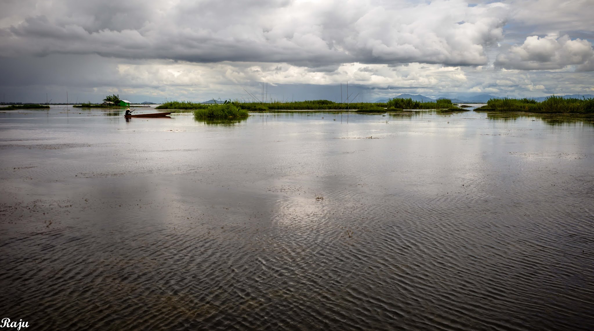
We took a car the next day, August 29, for Rs.2800, to get to LokTak Lake, a Indo-Nippon Peace Memorial and to a waterfall. Loktak Lake is about 50 km from Imphal, beyond Moirang.
 |
| Children near Loktak Lake, selling Lotus seeds and pods to passersby |
 |
| A view of the boating point at Sendra near Loktak Lake |
 |
| A view of a restaurant on a floating Phumidi at Loktak Lake. The circular masses of vegetation and soil are peculiar to this wetland region. |
 |
| A homestay on a floating Phumidi at Loktak Lake |
 |
| Fisherman at Loktak Lake collecting his catch. |
 |
| Fisherman at Loktak Lake. We were one of about 6-10 tourists that day. |
 |
View from the boat on Loktak Lake
|
 |
Restaurtant on floating phumidi at Loktak Lake. You can see the barrels supporting it under the pier.
|
Vendor selling dried fish inside the restaurant. Loktak lake supports about 100,000 people directly or indirectly who live around it.
 |
Another view of Loktak Lake from a high viewpoint.
 | | Yet another view of Loktak Lake from a high viewpoint. The circular phumdis are clearly visible. |
|
From there, we proceeded to the INA Memorial that was, unfortunately, closed. Subhas Chandra Bose, one of India's freedom fighters, had made inroads till here, fighting along with the Japanese Army against the British.

We went on with our journey to Sadu Chiru Waterfall. The access area around the waterfall itself was closed on account of COVID, or possibly because the villagers had decided to close access because of drunk Sunday revelers. The drive itself was picturesque.
 |
| Way to waterfall |
 |
| Local fruit wines and black rice wines in attractive bottles of whiskey. They stank to high heaven, and I left the black rice wine in the taxi when they dropped me. In any case, it was undrinkable and low alcoholic content. |
 |
| Sadu Chiru Waterfall to Imphal. The lonely hut in the middle of the fields seemed to command attention. |
 |
| Indo-Nippon Peace Museum to all the fallen Indian and Japanese soldiers in 1944. |
 |
| A plaque at the Indo-Nippon Peace Memorial |
 |
We had dinner at Cafe Classic, that came highly recommended from Trip Advisor for its traditional Manipuri Thali.
|
 |
| Cafe Classic's Manipuri Thali was a disappointment, bland and inspid, in spite of the great presentation. |
 |
| The only palatable stuff seemed to be these two desserts, with some sprinkling of taste. The one on the left was pineapple spoiled by some seeds on top, and the one on the right, a black rice pudding that left me wanting more sugar. |
We started out from Imphal for Nagaland on August 30 at 10 am, after waiting for the bus for an hour (since the person had asked us to be there by 9 am). The bus then stopped till 11 am at the Intercity State Bus Terminal, idly waiting to be filled up with more passengers. They charged us a whopping Rs.600 per head (official rate on receipt Rs.800) and prices seem to have gone up. The bus stopped for lunch at Singmai, where I also bought some of their renowned rice wine (42% v/v alcohol). We finally reached Dawn Homestay at Kigwema Village, some 20 km before Kohima, at 4 pm.
 |
| Dawn Homestay, Kigwema. |
We were finally in Kigwema, a village of the Angami tribe. None of the people of "Nagaland" call themselves "Nagas". All of them are Austro-asiatic in origin, sharing several language and cultural similarities with the South Asian tribes and peoples.
All of them have separate languages, cultures, gods, and traditions. In order to communicate with each other, they either use a pidgin language "Nagamese" which is a mixture of Bengali, Hindi and Assamese, or Ao (a Tibetan-Burman language), or Tenyidie (mostly used in Angami villages), or even English (the official language).
The word Naga came to be popular with the British in the 19th century, who preferred to clump all these diverse cultures and tribes under one umbrella, and the hills were referred to as Naga Hills.
 |
The brother of our hosts at Dawn Homestay, along with their cat.
|
 |
| The adorable cat at Dawn Homestay |
On August 31, we started out to Viswema Village, where there is a turn off for the Dzukou Valley trailhead. Viswema Village itself is about 20 minutes away from Kigwema, driving past Jakhama.
 |
| The turn off from Viswema Village towards Dzujou Valley trailhead. |
You can also do the trek starting from Jakhama village side, but the incline is steeper, and it is tougher. We elected to start from the Viswema side. A drive of an hour and a half that can be only done on a four wheel drive through a rocky trail takes us to the trailhead.
From the trailhead, the campsite of Dzukou Valley is about 4 hour trek up for a sedentary city dweller.
We started at 8:15 am and reached up at 12:00 am.
 |
| 600 meters over! |
Every once a while, you have stones carved with the number of meters you have already climbed!
 |
| Expand this photo, you will see a white cross at the right-center which is in the middle of Dzukou Valley |
 |
| Dormitory where most of the trekkers sleep at Dzukou Valley Campsite |
 |
| The registration stall at Dzukou Valley campsite |
 |
| This is the rate card at the Registration Stall for visitors to Dzukou Valley, for staying at the dormitory, pitching your own tent, using the kitchen, cooked food, etc. |
 |
Some basic stuff like biscuits, tea and Maggi are available at the registration stall
|
The clouds cleared suddenly at 3:45 pm, and we hastily decided to trek down to Dzukou Valley and come back. It took us a good 2:45 hours to trek down and climb back up to the campsite.
 |
| I had been trying to avoid getting my socks wet, in spite of wet puddles along the way, and managed till we had to cross a spring. The spring was waist deep, fast-flowing, and the only way you could cross it was with a rope strung across the banks. It was more of a deep rivulet and the bed was rocky. My shoes gave up their ghost of dryness in the spring and I sloshed my way back up! |
The trek down from Dzukou Campsite to Jakhama Village is an interminable 8000 footsteps, very steep. We descended on September 1, starting early at 8 am from the campsite, from 2600 meters (about 8500 feet) to 1650 meters (about 5,500 feet) in the space of 4.5 hours.
 |
| The descent was tough, with the trails muddy, slippery, rocky and mossy, and at times, I had to go down on all fours. Of course, the locals do it without a single misstep, often doing the descent in barely an hour. Our guide said half-an-hour is all it took him. While it rained intermittently all along the descent, it was perfectly doable. Some girls we had met the day before at our homestay said they took 7 hours to do the trail. |
 |
| At 55 years, I thought I grew old hiking, and as I ended the trek, once again wondered whatever made me trek? The pains in my legs reminded me that I was growing older. I was sweaty, tired, hungry, thirsty and sometimes wanting to sit down and die peacefully. Craziness and romantic thoughts afflict trekkers every once in a while! |
 |
At the end of the trail at the Jakhama side trailhead of Dzukou Valley
|
After coming back from Dzukou Valley on September 1, and discussing with Rovi, the part-owner of Dawn Homestay, we decided that the trek up to Japfu peak wouldn't be possible given the state of our legs. We went and instead visited Nagaland Heritage Village.
While the village itself is closed, the buildings (houses) of the 16 tribes are still there for anyone to wander around. The video is worth sifting through and is on Youtube titled
One Week in Manipur and Nagaland (click to follow link).
We then decided to go up to a town called Pfutsero about a 4 hour drive away, on September 2 morning. We would be back by 4 p.m. It is the highest altitude populated place in Nagaland and it is said that you can see Mt. Everest and Burma on a clear day from Glory Peak.
 |
| Pfutsero is inhabited by Kuzhas and Chokris, two of the other 16 tribes of Nagaland. |
 |
| Waterfall on the way to Pfutsero |
 |
Rovi, the part-owner of Dawn Homestay, who suggested going to Pfutsero, and decided to come along with us on a picnic because the homestay was relatively free that day.
|
 |
| Grass flowers by the side of the road. We had a puncture shortly after leaving Kigwema in the morning, with the sidewall of one of the tires exploding. Our stepney was also flat, so the driver called for a second car to pick us up from Kigwema and we were waiting. |
 |
| We had a second puncture on the second car and stopped while the driver changed the tire. I used the time to photograph these flowers by the side of the road. |
 |
| Pfutsero seen from a distance |
 |
| A vegetable stall near Pfutsero. There is no person manning the stall. Prices are written on labels and kept below the packets. You take whatever you want, and deposit your money in a locked box bound to the pole of the vegetable shop. The shop depends on your honesty to run. |
 |
| When we climbed up the tower to Glory Peak, we were in the middle of a cloud with hardly any visibility. Seeing Mt. Everest seemed a far cry, or even Burma for that matter! Our host, Rovi was in peals of laughter, at having suggested the entire trip to us. But the journey was worth it! |
 |
| The clouds were finally clearing up around Glory Peak and we could see the town of Pfutsero below us. |
 |
| A view of the trees around Glory Peak. We stopped and had lunch here, that was provided for free by Rovi, as she was picnicking with us. |
 |
| We wanted to stop at Lasumi village, and Rovi, our host kept trying to call her friend for permission. Effectively, all the villages of Nagaland have their own administration and outsiders are only allowed in with the permission of the village chairman. We found this practice even in Khonoma. |
 |
| A view of Lasumi village. We failed to contact anyone for permission, and skipped the visit to Lasumi Village. |
 |
| Stall outside a restaurant selling tomatos, mushrooms, and king chillies. |
 |
| Our host Rovi, our driver, Ashish and Koushik stopped for tea at a restaurant. |
 |
| I had snails and bees for dinner. At the top right is a snail shell, in the centre are a bee, and a cocoon of a bee. The bees taste better in cocoon state. In full grown state, their wings and legs gives a crunch in the mouth, and a possible gag reflex to people unused to eating insects (like me). |
 |
| Rovi in the kitchen of Dawn Homestay |
 |
| Dining Room of Dawn Homestay |
There is also a wooden fireplace and chimney in Dawn Homestay. The wooden fire is mostly used for heating kettles or for toasting corncobs grown in their fields. Most of the produce we ate came from their own fields.
We started from Kigwema on September 3 and passed Kohima (about 16 kms away) on our way to Khonoma, Dzuleke and a sheep farm beyond it, about 45 kms away from Kigwema.
 |
| A view of Kohima city, the capital of Nagaland |
 |
| A country liquor shop in Kohima that I visited in search of rice wine (yuthou). The rice wine smelled foul within a 8 hours when I finally opened the bottle, tasted like highly fermented buttermilk, was a pale whitish yellow, had almost no alcohol content, and had to be thrown out after one gulp. Maybe the overpowering smell wasn't there initially, and maybe I should have consumed it fresh. |
 |
| At Kohima market: these weevils were wriggling about inside plates. They seemed similar to pea leaf weevils, quite edible. I didn't find them fried or in some curry, and didn't want to try them raw. There were also live frogs, but once again, no fried frogs in the market. |
 |
| Every village has a "Gate" in Nagaland, with the tribe ensignia on the sides of the gate. This was an Angami "Green Village", one that was entirely plastic free, and where the Angamis had given up hunting in order to conserve animals for their succeeding generations. |
 |
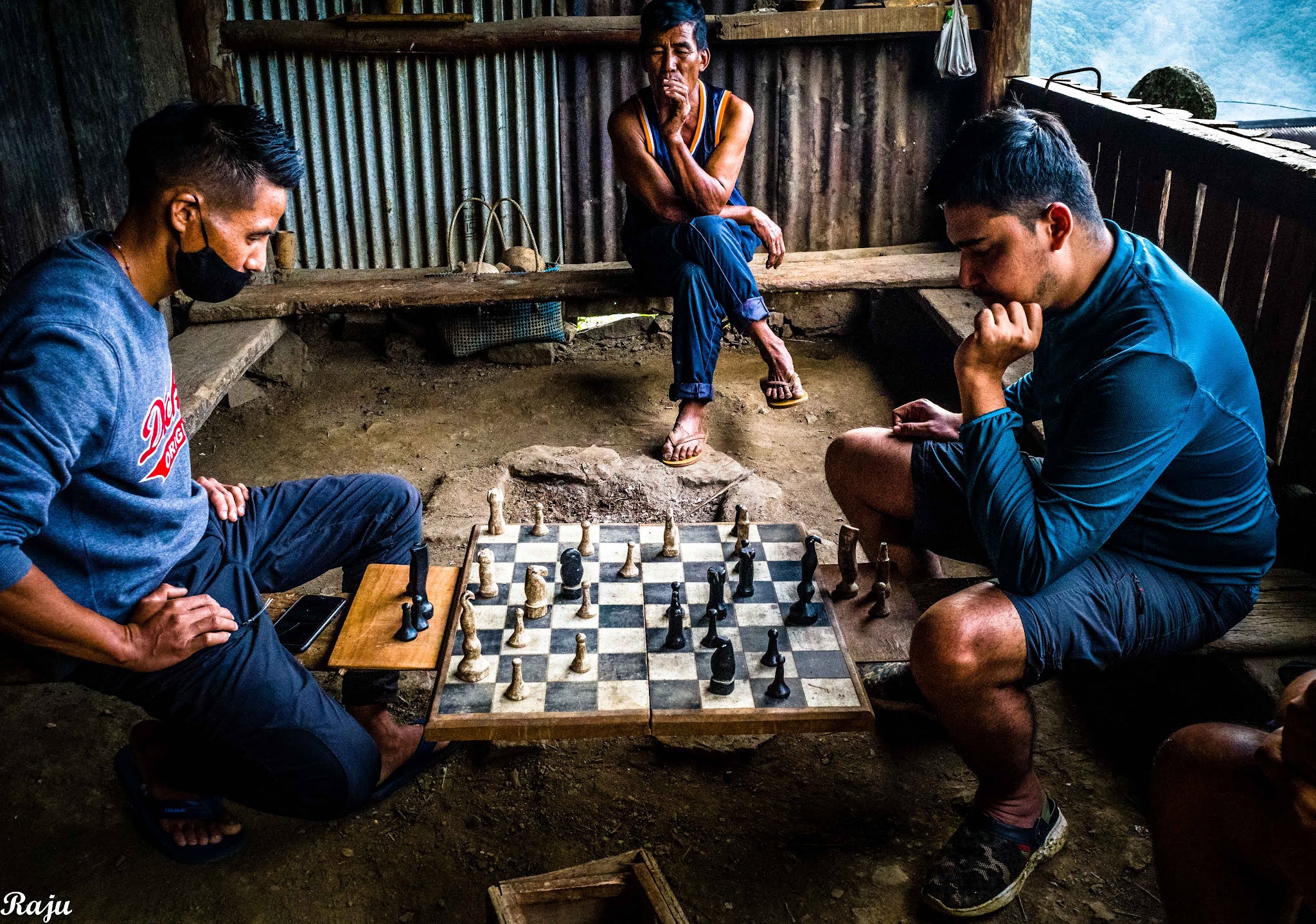
| Victor, the manager of Dovipie Inn, where we stayed, and an excellent chess player. |
 |
| The domitory of Doviepie Inn, where we stayed in Khonoma. |
 |
| Doviepie Inn, where we checked in before continuing on our way to Dzuleke. |
 |
| A typical outhouse adjacent to our inn, built rather in the style of an Angami Morung, with a fireplace in the middle for visitors to sit around and have drinks and talk. |
 |
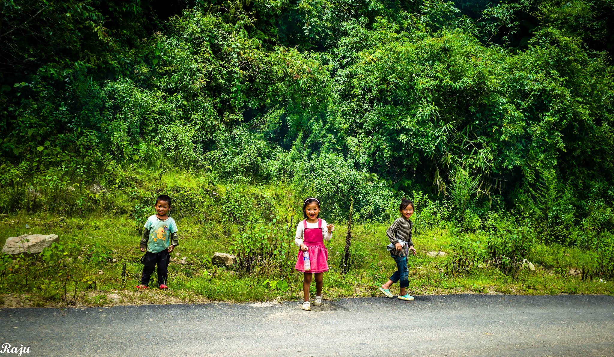
| Children are always very special! I stopped the car on the way to Dzuleke because I was enchanted by these girls! |
 |
| And they stood there and started posing for the Camera! |
 |
| Laughing away, uncaring about anything else in the world! My heart brims over with the joy these children can share. |
 |
| "Magar mujhko laute do bachpan ka sawan, woh kagaz ki kashti, woh baarish ka paani." |
 |
| Poilwa New Village where we went to visit a Sheep Farm |
 |
| The famed Sheep Farm. It's unusual to grow sheep in the hills, where plain surfaces can barely be found. The New Poilwa Sheep Farm is a quaint farm where some 50-odd sheep are being reared. Back in the distance, you can see a few sheep grazing. |
 |
| A lone goat with a limp stands in front of his shed. |
 |
| A view of Dzuleke Village |
 |
A view of the campsite near a stream in Dzuleke Village.
|
 |
| A wild Mithun shed. The shed contains some food and salt. It is used to provide a salt lick for Mithun. |
 |
| Mithun gather whenever a human blows a horn. In the morning, reportedly 100-300 of them come in, most probably because they know that salt licks are being provided for them. |
 |
| Mithun is the Nagaland State Animal. Often, houses have at least one set of Mithun horns on them. Recently, they have been designated a separate species, while earlier they were thought to be some mix between wild bison and water buffalo. |
 |
| Far off in the distance, on the cliff face, if you try hard, you can imagine a face with eyes and a smiling mouth! That, mythically, is the spirit that overlooks Khonoma Village, and safeguards it. |
 |
| The villagers woke up one fine day to find this rock embedded in the ground, and carved it since it was heaven-sent. |
 |
| This structure was a house built by one "age-group". There are several age groups, each with 5 years difference, of youth in Khonoma. |
Rocks play an important part in tradition. A rock can often commemorate a dead person, and sometimes even a long friendship or event.
 |
| Our dining room in Doviepie Inn |
 |
| A traditional house. |
 |
| A self-explanatory rock inscription about the founding of Khonoma Village |
 |
| A fort where a pitched battle was fought until it was finally conquered by the British. |
 |
| Men weave baskets. Women carry the heavy loads in the baskets! |
 |
| Randomly, wild cabbages can be growing out of walls! All that you need to do is stick a cabbage plant in a wall. |
 |
| Victor, our hotel manager, playing a chess game with Ashish, one of our team members. |
 |
| A game of footballs played high up in the hills at Sunset |
 |
| Sunset over the paddy fields. |
 |
| Abstract Art: Fire in the mountain! |
 |
| View from our dormitory window |
 |
| Visit to the Paddy Fields |
 |
| Spring near Khonoma Village |
 |
| Our room at Razhu Pru Hotel, a heritage place constructed a hundred years ago. |
 |
| Streets of Kohima, Sep 2021. |
 |
| Baptist Church, Kohima |
 |
| Another view of Kohima |
 |
| Chimney Hut restaurant menu |
 |
| Chimney Hut restaurant |
 |
| Made in Nagaland Emporium is a good place to visit. |


Beautiful photos and a wonderful blog.
ReplyDelete